
Lake Guntersville State Park topographic map
Interactive map
Click on the map to display elevation.
About this map
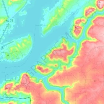
Name: Lake Guntersville State Park topographic map, elevation, terrain.
Average elevation: 242 m
Minimum elevation: 177 m
Maximum elevation: 359 m
Other topographic maps
Click on a map to view its topography, its elevation and its terrain.
Lindsay Lane
United States > Alabama > Marshall County > Guntersville
Lindsay Lane, Guntersville, Marshall County, Alabama, 35976, United States
Average elevation: 249 m
Wyeth City
United States > Alabama > Marshall County > Guntersville > Wyeth City
Wyeth City, Guntersville, Marshall County, Alabama, 35976, United States
Average elevation: 230 m
Guntersville
United States > Alabama > Marshall County > Guntersville
Guntersville, Marshall County, Alabama, 35976, United States
Average elevation: 208 m