
Make a donation
Baja California topographic map
Click on the map to display elevation.
Make a donation
Baja California
Baja California is the 12th-largest state by area in Mexico. Its geography ranges from beaches to forests and deserts. The backbone of the state is the Sierra de Baja California, where Picacho del Diablo, the highest point of the peninsula, is located. This mountain range effectively divides the weather patterns in the state. In the northwest, the weather is semi-dry and Mediterranean. In the narrow center, the weather changes to be more humid due to altitude. It is in this area where a few valleys can be found, such as the Valle de Guadalupe, the major wine-producing area in Mexico. To the east of the mountain range, the Sonoran Desert dominates the landscape. In the south, the weather becomes drier and gives way to the Vizcaíno Desert. The state is also home to numerous islands off both of its shores. Baja California is also home to Guadalupe Island, the westernmost point of Mexico. The Coronado Islands, Todos Santos islands, and Cedros Island are also on the Pacific shore. On the Gulf of California, the largest island is Angel de la Guarda Island, separated from the peninsula by the deep and narrow Canal de Ballenas.
Make a donation
About this map
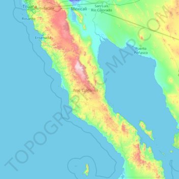
Name: Baja California topographic map, elevation, terrain.
Location: Baja California, Mexico (27.99999 -118.36506 32.71867 -112.75267)
Average elevation: 179 m
Minimum elevation: -11 m
Maximum elevation: 2,850 m
Make a donation
Other topographic maps
Click on a map to view its topography, its elevation and its terrain.
San Miguel el Alto
Mexico > Jalisco > San Miguel el Alto > San Miguel el Alto
Average elevation: 1,887 m
Make a donation
Make a donation
Jilotlan de los Dolores
Mexico > Jalisco > Jilotlán de los Dolores > Jilotlan de los Dolores
Average elevation: 862 m
Make a donation
Tamazula de Gordiano
Mexico > Jalisco > Tamazula de Gordiano > Tamazula de Gordiano
Average elevation: 1,222 m
Make a donation
San Sebastián del Sur
Mexico > Jalisco > Gómez Farías > San Sebastián del Sur
Average elevation: 1,623 m
Make a donation
Paseos del Valle
Mexico > Jalisco > Tlajomulco de Zuñiga > Santa Cruz del Valle > Paseos del Valle
Average elevation: 1,532 m
Atotonilco El Alto
Mexico > Jalisco > Atotonilco el Alto > Atotonilco El Alto
Average elevation: 1,712 m
Make a donation
Make a donation
San Diego de Alejandría
Mexico > Jalisco > San Diego de Alejandría > San Diego de Alejandría
Average elevation: 1,882 m
Unión de San Antonio
Mexico > Jalisco > Unión de San Antonio > Unión de San Antonio
Average elevation: 1,900 m
Make a donation
Delegación de la Pila
Mexico > San Luis Potosi > Municipio de San Luis Potosí > Delegación de la Pila
Average elevation: 1,868 m
Make a donation