
La Croix Verte topographic map
Interactive map
Click on the map to display elevation.
About this map
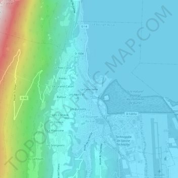
Name: La Croix Verte topographic map, elevation, terrain.
Average elevation: 399 m
Minimum elevation: 223 m
Maximum elevation: 1,373 m
Other topographic maps
Click on a map to view its topography, its elevation and its terrain.
La Matassine
France > Auvergne-Rhône-Alpes > Savoie > Le Bourget-du-Lac
La Matassine, Le Bourget-du-Lac, Chambéry, Savoie, Auvergne-Rhône-Alpes, France métropolitaine, 73370, France
Average elevation: 570 m
Noiray
France > Auvergne-Rhône-Alpes > Savoie > Le Bourget-du-Lac > Le Petit Caton
Noiray, Le Petit Caton, Le Bourget-du-Lac, Chambéry, Savoie, Auvergne-Rhône-Alpes, France métropolitaine, 73370, France
Average elevation: 541 m
La Roche Saint-Alban
France > Auvergne-Rhône-Alpes > Savoie > Le Bourget-du-Lac
La Roche Saint-Alban, Le Bourget-du-Lac, Chambéry, Savoie, Auvergne-Rhône-Alpes, France métropolitaine, 73370, France
Average elevation: 666 m
La Serraz
France > Auvergne-Rhône-Alpes > Savoie > Le Bourget-du-Lac
La Serraz, Le Bourget-du-Lac, Chambéry, Savoie, Auvergne-Rhône-Alpes, France métropolitaine, 73370, France
Average elevation: 523 m
Les Grangeons
France > Auvergne-Rhône-Alpes > Savoie > Le Bourget-du-Lac
Les Grangeons, Le Bourget-du-Lac, Chambéry, Savoie, Auvergne-Rhône-Alpes, France métropolitaine, 73370, France
Average elevation: 561 m
Charpignat
France > Auvergne-Rhône-Alpes > Savoie > Le Bourget-du-Lac > Charpignat
Charpignat, Le Bourget-du-Lac, Chambéry, Savoie, Auvergne-Rhône-Alpes, France métropolitaine, 73370, France
Average elevation: 461 m
Les Buissons
France > Auvergne-Rhône-Alpes > Savoie > Le Bourget-du-Lac
Les Buissons, Le Bourget-du-Lac, Chambéry, Savoie, Auvergne-Rhône-Alpes, France métropolitaine, 73370, France
Average elevation: 446 m
Sentier Botanique
France > Auvergne-Rhône-Alpes > Savoie > Le Bourget-du-Lac > Brédy
Sentier Botanique, Route du Relais, Rafour, Brédy, Le Bourget-du-Lac, Chambéry, Savoie, Auvergne-Rhône-Alpes, France métropolitaine, 73370, France
Average elevation: 632 m