
Make a donation
Hamedan topographic map
Click on the map to display elevation.
Make a donation
About this map
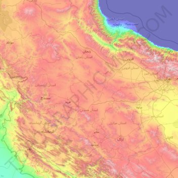
Name: Hamedan topographic map, elevation, terrain.
Location: Hamedan, Iran (32.83231 45.96651 38.03231 51.16651)
Average elevation: 1,465 m
Minimum elevation: -31 m
Maximum elevation: 4,553 m
Make a donation
Other topographic maps
Click on a map to view its topography, its elevation and its terrain.
Tehran
Iran > Tehran Province > Tehran County
Tehran, located in the northern part of Iran, is set against the backdrop of the Alborz mountain range, which towers prominently to the north. The city itself is perched at approximately 3,750 feet (1,143 meters) above sea level, providing a striking contrast between its urban landscape and the rugged terrain…
Average elevation: 1,539 m
Gorgan
Iran > Golestan Province > Gorgan County
Gorgan has a subtropical mediterranean climate (Köppen: Csa, Trewartha: Cs), with hot, humid summers and cool, wet winters. In general, Golestan has a moderate and humid climate known as "the moderate Caspian climate". The effective factors behind such a climate are Alborz mountain range, the direction of the…
Average elevation: 187 m
Isfahan
Iran > Isfahan Province > Isfahan County
Situated at 1,590 metres (5,217 ft) above sea level on the eastern side of the Zagros Mountains, Isfahan has a cold desert climate (Köppen BWk). No geological obstacles exist within 90 kilometres (56 miles) north of the city, allowing cool winds to blow from this direction. Despite its altitude, Isfahan…
Average elevation: 1,607 m
Tehran
Iran > Tehran Province > Tehran County
As the city has a large area, with significant differences in elevation among various districts, the weather is often cooler in the hilly north than in the flat southern part of Tehran. For instance, the 17.3 km (10.7 mi) Valiasr Street runs from Tehran's railway station at 1,117 m (3,665 ft) elevation above…
Average elevation: 1,539 m
Make a donation
Bandar Abbas
Iran > Hormozgan Province > Bandar-e-Abbas County
Bandar Abbas is situated on flat ground with an average altitude of 9 metres (30 ft) above sea level. The nearest elevated areas are Mt. Geno, 17 kilometres (11 mi) to the north, and Mt. Pooladi, 16 kilometres (9.9 mi) to the northwest of the city. The closest river to Bandar Abbas is the River Shoor, which…
Average elevation: 27 m
Make a donation
Shiraz
Iran > Fars Province > Shiraz County
Shiraz's climate has distinct seasons, and is overall classed as a cold semi-arid climate (Köppen climate classification BSk), though it is only a little short of a hot semi-arid climate (BSh) or a hot-summer Mediterranean climate (Köppen climate classification Csa). Summers are hot, with a July average high…
Average elevation: 1,785 m
Tabriz
Iran > East Azerbaijan Province > Tabriz County
Tabriz (Persian: تبریز [tæbˈɾiːz] (listen); Azerbaijani: تبریز) is a city in northwestern Iran, serving as the capital of East Azerbaijan Province. It is the sixth-most-populous city in Iran. In the Quru River valley in Iran's historic Azerbaijan region between long ridges of volcanic cones in…
Average elevation: 1,538 m
Make a donation
Tehran
Iran > Tehran Province > Tehran County
Northern Tehran is at the foot of Alborz, starting at an elevation of 1,800 meters (5,900 ft), with many houses and streets on steep slopes and hills. There is a stretch of hills in the middle of the city (which historically divided Tehran and Shemiran) with its highest point at 1,500 metres (4,900 ft).…
Average elevation: 1,539 m
Make a donation
Bandar Abbas
Iran > Hormozgan Province > Bandar-e-Abbas County
Bandar Abbas is situated on flat ground with an average altitude of 9 metres (30 ft) above sea level. The nearest elevated areas are Mt. Geno, 17 kilometres (11 mi) to the north, and Mt. Pooladi, 16 kilometres (9.9 mi) to the northwest of the city. The closest river to Bandar Abbas is the River Shoor, which…
Average elevation: 27 m
Kerman Province
The altitudes and heights of the province are the continuation of the central mountain ranges of Iran. They extend from the volcanic folds beginning in Azerbaijan and, by branching out in the central plateau of Iran, terminate in Baluchestan. These mountain ranges have brought about vast plains in the…
Average elevation: 1,150 m
Make a donation
Amol
Iran > Mazandaran Province > Amol County
Amol is located on the banks of the Haraz River (26 25'N 52 21'E) at an altitude of 76 m above the sea. It is about 18 km from the Caspian Sea and about 10 km from the northern Alborz mountains. It is 180 km from the Iranian capital, Tehran, with a picturesque drive through Haraz Road. Sari, the capital of…
Average elevation: 90 m
Make a donation
Tehran
Iran > Tehran Province > Tehran County
As the city has a large area, with significant differences in elevation among various districts, the weather is often cooler in the hilly north than in the flat southern part of Tehran. For instance, the 17.3 km (10.7 mi) Valiasr Street runs from Tehran's railway station at 1,117 m (3,665 ft) elevation above…
Average elevation: 1,539 m
Make a donation
Hamedan
Iran > Hamadan Province > Hamedan County
Hamadan spot (light blue in center) in Hamadan province topography map
Average elevation: 1,880 m
Jiroft
Iran > Kerman Province > Jiroft County
Jiroft is in a vast plain, Halil River, on the southern outskirts of the Jebal Barez mountain chain, surrounded by two rivers. The mean elevation of the city is about 650 metres (2,130 ft) above sea level. The weather of the city is sweltering in summer – it is one of the hottest places in Iran – but…
Average elevation: 692 m
Isfahan
Iran > Isfahan Province > Isfahan County
Situated at 1,590 metres (5,217 ft) above sea level on the eastern side of the Zagros Mountains, Isfahan has a cold desert climate (Köppen BWk). No geological obstacles exist within 90 kilometres (56 miles) north of the city, allowing cool winds to blow from this direction. Despite its altitude, Isfahan…
Average elevation: 1,607 m
Make a donation
دریاچه سد البرز (لفور)
Iran > Mazandaran Province > Babol County > دهستان لفور > اسبوکلا
Average elevation: 386 m
Jiroft
Iran > Kerman Province > Jiroft County
Jiroft lies in an alluvial plain of the Halil River, on the southern outskirts of the Jebal Barez mountain chain. It sits in a tectonically active basin, at the northern end of the Bandar Abbas-Jiroft fault zone, with both structural and anthropogenic subsidence occurring. Two intermittent streams join the…
Average elevation: 695 m
Make a donation
Isfahan
Iran > Isfahan Province > Isfahan County
Isfahan has a cold desert climate (Köppen: BWk), characterized by low annual precipitation, clear skies, strong sunlight, and large temperature fluctuations between day and night. The city, situated at an elevation of approximately 1,570 meters above sea level, experiences hot, dry summers and cool to cold…
Average elevation: 1,607 m
Make a donation
Pardisan Park
Iran > Sistan and Baluchestan Province > Zahedan County > Zahedan
Average elevation: 1,400 m
Varzaneh
Iran > Isfahan Province > Golpayegan County > Golshahr
Golpayegan (Persian: گلپایگان) is a city in the Central District of Golpayegan County, Isfahan, Iran, serving as capital of both the county and the district. The city is 186 kilometres (116 mi) northwest of Isfahan and 102 kilometres (63 mi) southeast of Arak, at an altitude of 1,830 m. Its temperature…
Average elevation: 1,780 m
Make a donation
Bandar Abbas
Iran > Hormozgan Province > Bandar-e-Abbas County
Bandar Abbas is situated on flat ground with an average altitude of 9 metres (30 ft) above sea level. The nearest elevated areas are Mt. Geno, 17 kilometres (11 mi) to the north, and Mt. Pooladi, 16 kilometres (9.9 mi) to the northwest of the city. The closest river to Bandar Abbas is the River Shoor, which…
Average elevation: 27 m
Tehran
Iran > Tehran Province > Tehran County
Northern Tehran is at the foot of Alborz, starting at an elevation of 1,800 meters (5,900 ft), with many houses and streets on steep slopes and hills. There is a stretch of hills in the middle of the city (which historically divided Tehran and Shemiran) with its highest point at 1,500 metres (4,900 ft).…
Average elevation: 1,539 m
Make a donation
Bandar Abbas
Iran > Hormozgan Province > Bandar-e-Abbas County
Bandar Abbas is situated on flat ground with an average altitude of 9 metres (30 ft) above sea level. The nearest elevated areas are Mt. Geno, 17 kilometres (11 mi) to the north, and Mt. Pooladi, 16 kilometres (9.9 mi) to the northwest of the city. The closest river to Bandar Abbas is the River Shoor, which…
Average elevation: 27 m
Mehestan
Iran > Alborz Province > Savojbolagh County
Mehestan is in the west of Alborz province at an altitude of 1,310 to 1,610 meters above sea level and between longitudes of 50 degrees 25 minutes and 50 degrees 55 minutes and latitudes of 35 degrees 45 minutes and 36 degrees 5 minutes. Hashtgerd plain generally has cold winters and hot and dry summers, but…
Average elevation: 1,425 m
Make a donation
Kohgiluye and Buyer Ahmad Province
The province is mostly mountainous in terrain, part of the Zagros range. The highest point is the Dena summit with a height of 5,109 metres. The mountain range of Dena, which reaches an elevation of 4,000 metres, is located in the province, and is covered with oak forests. Another mountain is Khamin or Khami,…
Average elevation: 1,408 m
Make a donation
Make a donation
Make a donation
Make a donation
Make a donation
Isfahan
Iran > Isfahan Province > Isfahan County
Situated at 1,590 metres (5,217 ft) above sea level on the eastern side of the Zagros Mountains, Isfahan has a cold desert climate (Köppen BWk). No geological obstacles exist within 90 kilometres (56 miles) north of the city, allowing cool winds to blow from this direction. Despite its altitude, Isfahan…
Average elevation: 1,607 m
Make a donation
Mahdishahr
Iran > Semnan Province > Mehdishahr County
Mehdishahr is on the southern slopes of the Alborz mountains. Here, the chain of Alborz mountains is very close to the desert of Dasht-e Kavir. Sangsar, specially the northern part of it, is completely mountainous with cold winters, heavy snowfalls but with mild summers. The distance between Sangsar city and…
Average elevation: 1,738 m
Dezful
Iran > Khuzestan Province > Dezful County
Dezful is 650 kilometers away from the national capital of Tehran and 155 kilometres away from Ahvaz, the provincial capital of Khuzestan. The city is located 300 kilometres from the Persian Gulf and is at an altitude of 143 meters.
Average elevation: 137 m
Make a donation
Qom
Iran > Qom Province > Qom County
The city's topography in the 10th century still reflected the evolutionary merging of the original six villages; these were still separated by fields. The town center was located in the village of Mamajjān, which was connected to other parts of the city on the other side of the river by four bridges. There…
Average elevation: 943 m
Tehran
Iran > Tehran Province > Tehran County
Northern Tehran is at the foot of Alborz, starting at an elevation of 1,800 meters (5,900 ft), with many houses and streets on steep slopes and hills. There is a stretch of hills in the middle of the city (which historically divided Tehran and Shemiran) with its highest point at 1,500 metres (4,900 ft).…
Average elevation: 1,539 m
Make a donation
Tehran Province
Tehran Province is situated in north-central Iran, lying on the southern slopes of the Alborz Mountains. The province’s location within the Alborz range gives it a diverse topography, with high mountains in the north and gradually descending plains toward the south. This geographical setting creates a varied…
Average elevation: 1,378 m
Make a donation
Khorramabad
Iran > Lorestan Province > Khorramabad County
Khorramabad has what is classed under the Köppen climate classification as a Hot-summer Mediterranean climate (Csa) climate. Its elevation is 1147.8 above sea level. Average annual precipitation is 511.06 and its average annual temperature is 17.21 Celsius.
Average elevation: 1,368 m
Make a donation
Qom
Iran > Qom Province > Qom County
The city's topography in the 10th century still reflected the evolutionary merging of the original six villages; these were still separated by fields. The town center was located in the village of Mamajjān, which was connected to other parts of the city on the other side of the river by four bridges. There…
Average elevation: 943 m
Make a donation
East Azerbaijan Province
The highest point in East Azerbaijan is the volcanic peak of Sahand Mountain at 3,707 m (12,162 ft) of elevation, lying south of Tabriz, whereas the lower-lying areas are around Garmadooz (Ahar). The hills and mountains of the province are divided into three ranges: the Qara Daq Mountains, the Sahand and…
Average elevation: 1,529 m
Make a donation