
Thank you for supporting this site ❤️
Make a donation
Make a donation
Fars Province topographic map
Click on the map to display elevation.
Thank you for supporting this site ❤️
Make a donation
Make a donation
About this map
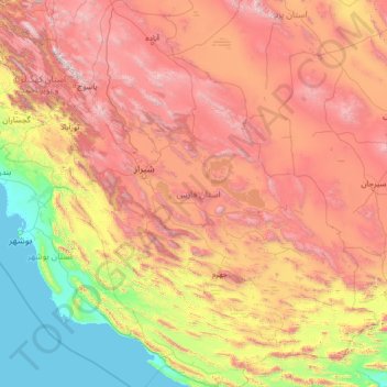
Name: Fars Province topographic map, elevation, terrain.
Location: Fars Province, Iran (27.06802 50.60318 31.66964 55.73296)
Average elevation: 1,339 m
Minimum elevation: -2 m
Maximum elevation: 4,174 m
Thank you for supporting this site ❤️
Make a donation
Make a donation
Other topographic maps
Click on a map to view its topography, its elevation and its terrain.
Baba Jan, East Azerbaijan
Iran > East Azerbaijan Province > Ahar County > دهستان قشلاق
Average elevation: 1,752 m
Thank you for supporting this site ❤️
Make a donation
Make a donation
Shoushtar
Iran > Khuzestan Province > Shushtar County > دهستان سردارآباد > Shoushtar
Average elevation: 75 m
Esfidan
Iran > North Khorasan Province > Bojnurd County > دهستان گرمخان > Esfidan
Average elevation: 1,743 m