
Thank you for supporting this site ❤️
Make a donation
Make a donation
Setúbal (São Sebastião) topographic map
Click on the map to display elevation.
Thank you for supporting this site ❤️
Make a donation
Make a donation
About this map
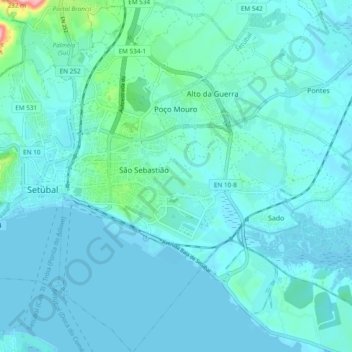
Name: Setúbal (São Sebastião) topographic map, elevation, terrain.
Location: Setúbal (São Sebastião), Setúbal, Portugal (38.48963 -8.88902 38.56415 -8.82730)
Average elevation: 22 m
Minimum elevation: -1 m
Maximum elevation: 221 m
Thank you for supporting this site ❤️
Make a donation
Make a donation
Other topographic maps
Click on a map to view its topography, its elevation and its terrain.
Thank you for supporting this site ❤️
Make a donation
Make a donation
Palácio e Quinta da Bacalhoa
Portugal > Setúbal > Setúbal > Vila Fresca de Azeitão
Average elevation: 122 m
Thank you for supporting this site ❤️
Make a donation
Make a donation
Thank you for supporting this site ❤️
Make a donation
Make a donation
Thank you for supporting this site ❤️
Make a donation
Make a donation