
Thank you for supporting this site ❤️
Make a donation
Make a donation
São Luís topographic map
Click on the map to display elevation.
Thank you for supporting this site ❤️
Make a donation
Make a donation
About this map
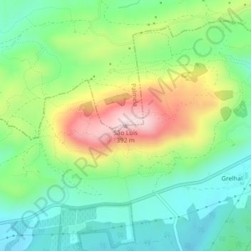
Name: São Luís topographic map, elevation, terrain.
Location: São Luís, Setúbal, 2951-901, Portugal (38.53345 -8.93870 38.53355 -8.93860)
Average elevation: 159 m
Minimum elevation: 36 m
Maximum elevation: 381 m
Thank you for supporting this site ❤️
Make a donation
Make a donation
Other topographic maps
Click on a map to view its topography, its elevation and its terrain.
Palácio e Quinta da Bacalhoa
Portugal > Setúbal > Setúbal > Vila Fresca de Azeitão
Average elevation: 122 m
Thank you for supporting this site ❤️
Make a donation
Make a donation