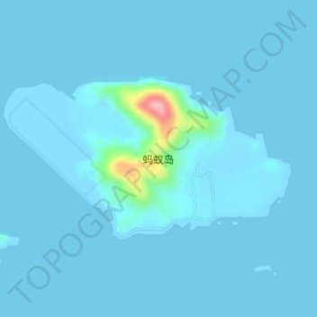
Geolocate

蚂蚁岛 topographic map

Interactive map

Click on the map to display elevation.

About this map

Name: 蚂蚁岛 topographic map, elevation, terrain.

Location: 蚂蚁岛, 舟山群岛新区, 普陀区, 舟山市, 浙江省, 中国 (29.86446 122.24438 29.87816 122.27260)

Average elevation: 7 m

Minimum elevation: -3 m

Maximum elevation: 142 m

Other topographic maps

Click on a map to view its topography, its elevation and its terrain.

湖泥山岛

中国 > 浙江省 > 普陀区

湖泥山岛, 舟山群岛新区, 普陀区, 舟山市, 浙江省, 中国

Average elevation: 3 m

西峰岛

中国 > 浙江省 > 普陀区

西峰岛, 舟山群岛新区, 普陀区, 舟山市, 浙江省, 中国

Average elevation: 20 m

元山岛

中国 > 浙江省 > 普陀区

元山岛, 普陀区, 舟山市, 浙江省, 中国

Average elevation: 8 m

白沙山

中国 > 浙江省 > 普陀区

白沙山, 舟山群岛新区, 普陀区, 舟山市, 浙江省, 中国

Average elevation: 5 m

登步岛

中国 > 浙江省 > 普陀区

登步岛, 普陀区, 舟山市, 浙江省, 中国

Average elevation: 11 m

六横岛

中国 > 浙江省 > 普陀区

六横岛, 普陀区, 舟山市, 浙江省, 中国

Average elevation: 14 m

虾峙岛

中国 > 浙江省 > 普陀区

虾峙岛, 普陀区, 舟山市, 浙江省, 中国

Average elevation: 13 m

朱家尖岛

中国 > 浙江省 > 普陀区

朱家尖岛, 普陀区, 舟山市, 浙江省, 中国

Average elevation: 14 m