
Mobile County topographic map
Interactive map
Click on the map to display elevation.
About this map
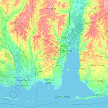
Name: Mobile County topographic map, elevation, terrain.
Location: Mobile County, Alabama, United States (30.14338 -88.43201 31.17337 -87.92420)
Average elevation: 25 m
Minimum elevation: -3 m
Maximum elevation: 110 m
Other topographic maps
Click on a map to view its topography, its elevation and its terrain.
Huntsville
United States > Alabama > Madison County
Huntsville, Madison County, Alabama, United States
Average elevation: 230 m
Birmingham
United States > Alabama > Jefferson County
Birmingham, Jefferson County, Alabama, United States
Average elevation: 193 m
Foley
United States > Alabama > Baldwin County
Foley, Baldwin County, Alabama, United States
Average elevation: 20 m
Fairhope
United States > Alabama > Baldwin County > Fairhope
Fairhope, Baldwin County, Alabama, United States
Average elevation: 35 m
Dauphin Island
United States > Alabama > Mobile County
Dauphin Island, Mobile County, Alabama, 36528, United States
Average elevation: 0 m
Jefferson County
Jefferson County, Alabama, United States
Average elevation: 173 m
Gurley
United States > Alabama > Madison County
Gurley, Madison County, Alabama, United States
Average elevation: 234 m
Dees
United States > Alabama > Mobile County
Dees, Mobile County, Alabama, United States
Average elevation: 33 m
Semmes
United States > Alabama > Mobile County
Semmes, Mobile County, Alabama, 36663, United States
Average elevation: 59 m
Greer
United States > Alabama > Elmore County
Greer, Elmore County, Alabama, United States
Average elevation: 150 m
Dauphin Island
United States > Alabama > Mobile County
Dauphin Island, Mobile County, Alabama, 36528, United States
Average elevation: 0 m
Trenton
United States > Alabama > Jackson County
Trenton, Jackson County, Alabama, 35774, United States
Average elevation: 250 m
Woodville
United States > Alabama > Jackson County
Woodville, Jackson County, Alabama, 29893, United States
Average elevation: 212 m
Acipcoville
United States > Alabama > Jefferson County > Birmingham
Acipcoville, Birmingham, Jefferson County, Alabama, 35207, United States
Average elevation: 190 m
Daphne
United States > Alabama > Baldwin County
Daphne, Baldwin County, Alabama, 36526, United States
Average elevation: 25 m
Walley
United States > Alabama > Washington County
Walley, Washington County, Alabama, United States
Average elevation: 73 m
Hytop
United States > Alabama > Jackson County
Hytop, Jackson County, Alabama, United States
Average elevation: 413 m
Princeton
United States > Alabama > Jackson County
Princeton, Jackson County, Alabama, 35766, United States
Average elevation: 273 m
Pelham
United States > Alabama > Shelby County
Pelham, Shelby County, Alabama, 35124, United States
Average elevation: 173 m
Hawaii Island
United States > Alabama > Tallapoosa County
Hawaii Island, Tallapoosa County, Alabama, United States
Average elevation: 149 m
Fultondale
United States > Alabama > Jefferson County
Fultondale, Jefferson County, Alabama, 35068, United States
Average elevation: 185 m
Watson
United States > Alabama > Jefferson County
Watson, Jefferson County, Alabama, 35181, United States
Average elevation: 164 m
Alton
United States > Alabama > Jefferson County > Irondale
Alton, Irondale, Jefferson County, Alabama, 35235, United States
Average elevation: 242 m
North Johns
United States > Alabama > Jefferson County
North Johns, Jefferson County, Alabama, United States
Average elevation: 151 m
Morris
United States > Alabama > Jefferson County
Morris, Jefferson County, Alabama, United States
Average elevation: 140 m
Westfield
United States > Alabama > Jefferson County
Westfield, Jefferson County, Alabama, 35064, United States
Average elevation: 187 m
Elyton
United States > Alabama > Jefferson County > Birmingham
Elyton, Birmingham, Jefferson County, Alabama, 35201, United States
Average elevation: 182 m
Chalkville
United States > Alabama > Jefferson County > Clay
Chalkville, Clay, Jefferson County, Alabama, 35235, United States
Average elevation: 279 m
Shannon
United States > Alabama > Jefferson County > Hoover
Shannon, Hoover, Jefferson County, Alabama, 35142, United States
Average elevation: 230 m
Robbins Crossroads
United States > Alabama > Jefferson County
Robbins Crossroads, Jefferson County, Alabama, 35139, United States
Average elevation: 136 m
Corner
United States > Alabama > Jefferson County
Corner, Jefferson County, Alabama, United States
Average elevation: 213 m
Bradford
United States > Alabama > Jefferson County
Bradford, Jefferson County, Alabama, United States
Average elevation: 170 m
Bayview
United States > Alabama > Jefferson County > Mulga
Bayview, Mulga, Jefferson County, Alabama, 35005, United States
Average elevation: 174 m
Acton
United States > Alabama > Jefferson County
Acton, Jefferson County, Alabama, 35243, United States
Average elevation: 172 m
Minor
United States > Alabama > Jefferson County > McDonald Chapel > Minor
Minor, McDonald Chapel, Jefferson County, Alabama, United States
Average elevation: 180 m
Forestdale
United States > Alabama > Jefferson County > Forestdale
Forestdale, Jefferson County, Alabama, 35214, United States
Average elevation: 185 m
West Jefferson
United States > Alabama > Jefferson County
West Jefferson, Jefferson County, Alabama, United States
Average elevation: 116 m
Cardiff
United States > Alabama > Jefferson County
Cardiff, Jefferson County, Alabama, United States
Average elevation: 144 m
Sayre
United States > Alabama > Jefferson County
Sayre, Jefferson County, Alabama, 35139, United States
Average elevation: 116 m
Palmerdale
United States > Alabama > Jefferson County > Pinson
Palmerdale, Pinson, Jefferson County, Alabama, 35126, United States
Average elevation: 254 m
New Castle
United States > Alabama > Jefferson County > Gardendale
New Castle, Gardendale, Jefferson County, Alabama, 35119, United States
Average elevation: 195 m
Kimbrell
United States > Alabama > Jefferson County
Kimbrell, Jefferson County, Alabama, 35111, United States
Average elevation: 162 m
Hopewell
United States > Alabama > Jefferson County > Bessemer
Hopewell, Bessemer, Jefferson County, Alabama, 35022, United States
Average elevation: 168 m
Flat Top
United States > Alabama > Jefferson County > Adamsville
Flat Top, Adamsville, Jefferson County, Alabama, 35011, United States
Average elevation: 110 m
Fieldstown
United States > Alabama > Jefferson County
Fieldstown, Jefferson County, Alabama, 35117, United States
Average elevation: 170 m
Docena
United States > Alabama > Jefferson County
Docena, Jefferson County, Alabama, 35060, United States
Average elevation: 181 m
Coalburg
United States > Alabama > Jefferson County
Coalburg, Jefferson County, Alabama, 35214, United States
Average elevation: 169 m
Stevenson
United States > Alabama > Jackson County
Stevenson, Jackson County, Alabama, 35772, United States
Average elevation: 242 m