Geolocate

石浦镇 topographic map

Interactive map

Click on the map to display elevation.

About this map

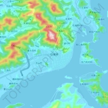
Name: 石浦镇 topographic map, elevation, terrain.

Location: 石浦镇, 宁波市, 浙江省, 315731, 中国 (29.16622 121.88718 29.24622 121.96718)

Average elevation: 53 m

Minimum elevation: -2 m

Maximum elevation: 388 m

Other topographic maps

Click on a map to view its topography, its elevation and its terrain.

火炉山

中国 > 浙江省 > 宁波市

火炉山, 宁波市, 浙江省, 中国

Average elevation: 40 m

园山

中国 > 浙江省 > 宁波市

园山, 宁波市, 浙江省, 中国

Average elevation: 310 m

奉化江

中国 > 浙江省 > 宁波市

奉化江, 宁波市, 浙江省, 中国

Average elevation: 5 m

青虎湾岗

中国 > 浙江省 > 宁波市

青虎湾岗, 宁波市, 浙江省, 中国

Average elevation: 721 m

东山

中国 > 浙江省 > 宁波市

东山, 宁波市, 浙江省, 中国

Average elevation: 91 m

庙岭

中国 > 浙江省 > 宁波市

庙岭, 宁波市, 浙江省, 中国

Average elevation: 43 m

西尖

中国 > 浙江省 > 宁波市

西尖, 宁波市, 浙江省, 中国

Average elevation: 724 m

鄞江镇

中国 > 浙江省 > 宁波市

鄞江镇, 海曙区, 宁波市, 浙江省, 中国

Average elevation: 74 m