
Eastern Region topographic map
Interactive map
Click on the map to display elevation.
About this map
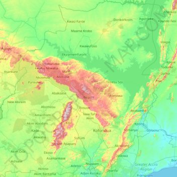
Name: Eastern Region topographic map, elevation, terrain.
Location: Eastern Region, Ghana (5.70084 -1.24707 7.21284 0.21658)
Average elevation: 165 m
Minimum elevation: -1 m
Maximum elevation: 827 m
Other topographic maps
Click on a map to view its topography, its elevation and its terrain.
La
Ghana > Greater Accra Region > La-Dade-Kotopon Municipal District > Accra > La
Average elevation: 16 m