
雪山乡 topographic map
Interactive map
Click on the map to display elevation.
About this map
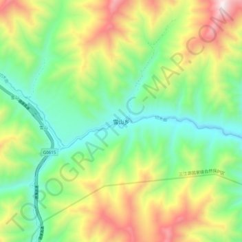
Name: 雪山乡 topographic map, elevation, terrain.
Location: 雪山乡, 玛沁县, 果洛藏族自治州, 青海省, 中国 (34.75470 99.68620 34.83470 99.76620)
Average elevation: 4,107 m
Minimum elevation: 3,599 m
Maximum elevation: 4,974 m
Other topographic maps
Click on a map to view its topography, its elevation and its terrain.