
West Richland topographic map
Interactive map
Click on the map to display elevation.
About this map
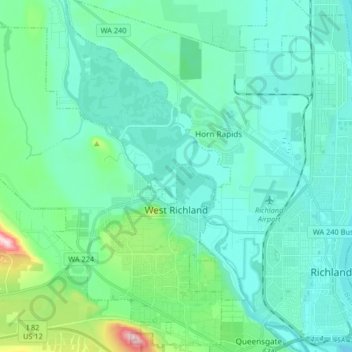
Name: West Richland topographic map, elevation, terrain.
Average elevation: 146 m
Minimum elevation: 93 m
Maximum elevation: 424 m
The original people of the region were the Chemnapum Indians (closely related to the Wanapum tribe), living near the mouth of the Yakima River. Lewis and Clark passed through the area in 1805, and an expedition of the Army Corps of Topographical Engineers headed by Robert E Johnson mapped the Yakima Valley in 1841.
Other topographic maps
Click on a map to view its topography, its elevation and its terrain.
Kennewick
United States > Washington > Benton County
Kennewick, Benton County, Washington, United States
Average elevation: 154 m
Hanford
United States > Washington > Benton County
Hanford, Benton County, Washington, United States
Average elevation: 123 m
Badger
United States > Washington > Benton County
Badger, Benton County, Washington, United States
Average elevation: 246 m
Kiona
United States > Washington > Benton County
Kiona, Benton County, Washington, 99320, United States
Average elevation: 224 m
North Prosser
United States > Washington > Benton County
North Prosser, Benton County, Washington, 99350, United States
Average elevation: 231 m
Plymouth
United States > Washington > Benton County
Plymouth, Benton County, Washington, 99346, United States
Average elevation: 105 m
Longview
United States > Washington > Benton County
Longview, Benton County, Washington, United States
Average elevation: 99 m
Highland
United States > Washington > Benton County
Highland, Benton County, Washington, United States
Average elevation: 196 m
Whistran Wildlife Area
United States > Washington > Benton County
Whistran Wildlife Area, Benton County, Washington, United States
Average elevation: 233 m
Finley
United States > Washington > Benton County
Finley, Benton County, Washington, United States
Average elevation: 115 m
Paterson
United States > Washington > Benton County
Paterson, Benton County, Washington, United States
Average elevation: 125 m
Benton City
United States > Washington > Benton County
Benton City, Benton County, Washington, United States
Average elevation: 190 m
Kennewick
United States > Washington > Benton County > Kennewick
Kennewick, Benton County, Washington, 99337, United States
Average elevation: 224 m
Prosser
United States > Washington > Benton County > Prosser > Prosser
Prosser, Benton County, Washington, 99350-1300, United States
Average elevation: 294 m
Richland
United States > Washington > Benton County
Richland, Benton County, Washington, United States
Average elevation: 160 m
Prosser
United States > Washington > Benton County
Prosser, Benton County, Washington, 99350, United States
Average elevation: 280 m
Audrey
United States > Washington > Benton County
Audrey, Benton County, Washington, United States
Average elevation: 156 m