
Make a donation
Hebron topographic map
Click on the map to display elevation.
Make a donation
Hebron
Hebron sits at the north end of Newfound Lake, the fourth-largest lake in New Hampshire. The Cockermouth River, the primary feeder to the lake, enters the town from Groton to the west and passes the town center before entering the lake. Hebron lies fully within the Merrimack River watershed. The highest point in Hebron is a knob with an elevation of 2,240 feet (680 m) above sea level just south of the summit of Tenney Mountain, near the town's northernmost point.
Make a donation
About this map
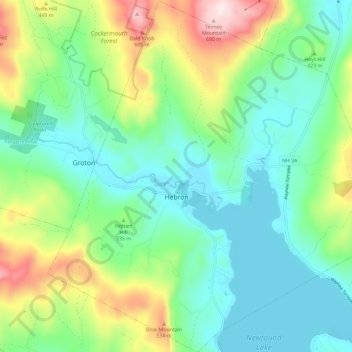
Name: Hebron topographic map, elevation, terrain.
Location: Hebron, Grafton County, New Hampshire, 03241, United States (43.65687 -71.84812 43.74075 -71.73392)
Average elevation: 327 m
Minimum elevation: 172 m
Maximum elevation: 706 m
Make a donation
Other topographic maps
Click on a map to view its topography, its elevation and its terrain.
Stinson Lake
United States > New Hampshire > Grafton County > Rumney > Stinson Lake
Average elevation: 460 m
Make a donation
Make a donation
Make a donation
Make a donation
Campton Lower Village
United States > New Hampshire > Grafton County > Campton
Average elevation: 260 m
Make a donation
Campton Hollow
United States > New Hampshire > Grafton County > Campton > Campton Hollow
Average elevation: 251 m
Make a donation
Make a donation
Corcoran Pond
United States > New Hampshire > Grafton County > Waterville Valley
Average elevation: 522 m
Waterville Valley
United States > New Hampshire > Grafton County > Waterville Valley > Waterville Valley
Average elevation: 567 m
Make a donation
Woodstock
United States > New Hampshire > Grafton County > Woodstock > Woodstock
Average elevation: 333 m
Make a donation