
Tikichourt topographic map
Interactive map
Click on the map to display elevation.
About this map
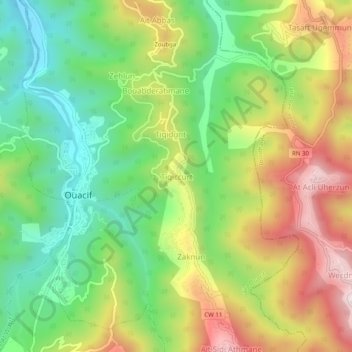
Name: Tikichourt topographic map, elevation, terrain.
Location: Tikichourt, Ouacif, Daïra Ouacif, Tizi Ouzou, 15015, Algérie (36.50592 4.19882 36.54592 4.23882)
Average elevation: 556 m
Minimum elevation: 294 m
Maximum elevation: 913 m
Other topographic maps
Click on a map to view its topography, its elevation and its terrain.
Aït Sidi Athmane
Algérie > Tizi Ouzou > Daïra Ouacif > Ouacif
Aït Sidi Athmane, Ouacif, Daïra Ouacif, Tizi Ouzou, 15015, Algérie
Average elevation: 783 m