
Wayanad District topographic map
Interactive map
Click on the map to display elevation.
About this map
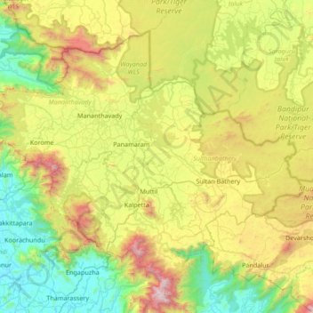
Name: Wayanad District topographic map, elevation, terrain.
Location: Wayanad District, Kerala, India (11.45136 75.77316 11.97868 76.44353)
Average elevation: 724 m
Minimum elevation: 8 m
Maximum elevation: 2,270 m
Wayanad (IPA: [ʋɐjɐnaːɖɨ̆]) is a district in the north-east of Indian state Kerala with administrative headquarters at the municipality of Kalpetta. It is the only plateau in Kerala. The Wayanad Plateau forms a continuation of the Mysore Plateau, the southern portion of Deccan Plateau. It is set high in the Western Ghats with altitudes ranging from 700 to 2100 meters. Vellari Mala, a 2,240 m (7,349 ft) high peak situated on the trijunction of Wayanad, Malappuram, and Kozhikode districts, is the highest point in Wayanad district. The district was formed on 1 November 1980 as the 12th district in Kerala, by carving out areas from Kozhikode and Kannur districts. An area of 885.92 km2 of the district is forested. Wayanad has three municipal towns—Kalpetta, Mananthavady and Sulthan Bathery. There are many indigenous tribes in this area. The Kabini River, a tributary of Kaveri River, originates at Wayanad. Wayanad district, along with the Chaliyar valley in neighbouring Nilambur (Eastern Eranad region) in Malappuram district, is known for natural gold fields, which are also seen in other parts of the Nilgiri Biosphere Reserve. Chaliyar river, which is the fourth longest river of Kerala, originates on the Wayanad plateau. The historically important Edakkal Caves are located in Wayanad district.
Other topographic maps
Click on a map to view its topography, its elevation and its terrain.
Thiruvananthapuram
India > Kerala > Thiruvananthapuram
Thiruvananthapuram, Thiruvananthapuram District, Kerala, 695001, India
Average elevation: 33 m
Western Ghats
Western Ghats, Idukki, Kerala, 685614, India
Average elevation: 2,225 m
Vagamon Lake
India > Kerala > Peerumade > Vagamon
Vagamon Lake, Vagamon, Peerumade, Idukki District, Kerala, India
Average elevation: 976 m
Thodupuzha
India > Kerala > Thodupuzha
Thodupuzha, Idukki District, Kerala, 685584, India
Average elevation: 53 m
Suryanelli
India > Kerala > Udumbanchola
Suryanelli, Udumbanchola, Idukki District, Kerala, India
Average elevation: 1,553 m
Kottakombur
Kottakombur, Devikulam, Idukki District, Kerala, India
Average elevation: 1,919 m
Irinjalakuda
India > Kerala > Mukundapuram
Irinjalakuda, Mukundapuram, Thrissur District, Kerala, 680100, India
Average elevation: 7 m
chullimanoor
India > Kerala > Nedumangad
chullimanoor, Nedumangad, Thiruvananthapuram District, Kerala, 695541, India
Average elevation: 94 m
Santhanpara
India > Kerala > Udumbanchola > Choondal
Santhanpara, Choondal, Udumbanchola, Idukki District, Kerala, India
Average elevation: 1,111 m
Poopara
India > Kerala > Udumbanchola
Poopara, Udumbanchola, Idukki District, Kerala, 685619, India
Average elevation: 1,140 m
Puthencruz
India > Kerala > Kunnathunad
Puthencruz, Kunnathunad, Ernakulam District, Kerala, 682308, India
Average elevation: 25 m
Kallara
India > Kerala > Nedumangad
Kallara, Nedumangad, Thiruvananthapuram District, Kerala, 695610, India
Average elevation: 110 m
sree krishna swami temple pond
India > Kerala > Karthikappally > Kayamkulam
sree krishna swami temple pond, Puthuvel Harijan Colony, Kayamkulam, Karthikappally, Alappuzha District, Kerala, India
Average elevation: 9 m
Murikkumthotti
India > Kerala > Udumbanchola
Murikkumthotti, Udumbanchola, Idukki District, Kerala, 685619, India
Average elevation: 1,099 m
Cheruthapullur Kulam
Cheruthapullur Kulam, Alathur, Palakkad District, Kerala, India
Average elevation: 90 m
kanthaloor pond 2
India > Kerala > Ottappalam > Vellinezhi
kanthaloor pond 2, Vellinezhi, Ottappalam, Palakkad District, Kerala, India
Average elevation: 58 m
Mathoor
India > Kerala > Alathur > Kuzhalmannam
Mathoor, Kuzhalmannam, Alathur, Palakkad District, Kerala, 678571, India
Average elevation: 75 m
Parumala
India > Kerala > Thiruvalla
Parumala, Thiruvalla, Pathanamthitta District, Kerala, 689626, India
Average elevation: 6 m
Nellor Pond
India > Kerala > Chengannur
Nellor Pond, Chengannur, Alappuzha District, Kerala, India
Average elevation: 6 m
Rajakkad
India > Kerala > Udumbanchola > Kalungu City
Rajakkad, Kalungu City, Udumbanchola, Idukki District, Kerala, 685566, India
Average elevation: 855 m
Palvelicham
India > Kerala > Mananthavady
Palvelicham, Mananthavady, Wayanad District, Kerala, India
Average elevation: 735 m
Adivaram
India > Kerala > Thamarassery
Adivaram, Thamarassery, Kozhikode District, Kerala, 673586, India
Average elevation: 301 m
Karumalloor
India > Kerala > Paravur > Manjaly
Karumalloor, Manjaly, Paravur, Ernakulam District, Kerala, India
Average elevation: 7 m
Velliangiri
Velliangiri, Mannarkad, Palakkad District, Kerala, India
Average elevation: 1,307 m
Vellarikundu
India > Kerala > Vellarikkundu > Kadumeni
Vellarikundu, Kadumeni, Vellarikkundu, Kasaragod District, Kerala, India
Average elevation: 85 m
Rajakumari
India > Kerala > Udumbanchola
Rajakumari, Udumbanchola, Idukki District, Kerala, 685619, India
Average elevation: 1,001 m
Charakadvu
India > Kerala > Hosdurg > Karuvakkode
Charakadvu, Karuvakkode, Hosdurg, Kasaragod District, Kerala, 671316, India
Average elevation: 25 m
Vavadukkam
India > Kerala > Kasaragod > Bedadka
Vavadukkam, Bedadka, Kasaragod, Kasaragod District, Kerala, India
Average elevation: 133 m
Elanthoor
India > Kerala > Kozhencherry
Elanthoor, Kozhencherry, Pathanamthitta District, Kerala, 689643, India
Average elevation: 38 m
Pallikkara
India > Kerala > Kunnathunad
Pallikkara, Kunnathunad, Ernakulam District, Kerala, 683565, India
Average elevation: 12 m
Kottakkani
Kottakkani, Hosdurg, Kasaragod District, Kerala, 671316, India
Average elevation: 23 m
Kizhakkekallada
Kizhakkekallada, Kollam, Kollam District, Kerala, 691502, India
Average elevation: 10 m
Muttukadu colony
India > Kerala > Udumbanchola
Muttukadu colony, Udumbanchola, Idukki District, Kerala, India
Average elevation: 1,193 m
Kundumkuzhy
Kundumkuzhy, Kasaragod, Kasaragod District, Kerala, 671541, India
Average elevation: 137 m
Kuruva Island
India > Kerala > Sulthanbathery
Kuruva Island, Sulthanbathery, Wayanad District, Kerala, India
Average elevation: 733 m
Pond at Kundamkuzhy near town
India > Kerala > Kasaragod > Kundumkuzhy
Pond at Kundamkuzhy near town, Kundumkuzhy, Kasaragod, Kasaragod District, Kerala, India
Average elevation: 146 m
Beericheri
Beericheri, Hosdurg, Kasaragod District, Kerala, 671311, India
Average elevation: 7 m