
Pampady topographic map
Interactive map
Click on the map to display elevation.
About this map
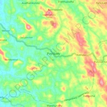
Name: Pampady topographic map, elevation, terrain.
Location: Pampady, Kottayam, Kottayam District, Kerala, 686502, India (9.52563 76.60436 9.60563 76.68436)
Average elevation: 55 m
Minimum elevation: 4 m
Maximum elevation: 135 m
Other topographic maps
Click on a map to view its topography, its elevation and its terrain.
Puthuppally
Puthuppally, Kottayam, Kerala, 686011, India
Average elevation: 18 m
Thiruvanchoor
India > Kerala > Kottayam > Thiruvanchoor
Thiruvanchoor, Kottayam, Kerala, 686637, India
Average elevation: 11 m
Karappuzha Temple Kulam
India > Kerala > Kottayam > Kottayam
Karappuzha Temple Kulam, Kottayam, Kerala, India
Average elevation: 6 m
Mattakkara
India > Kerala > Kottayam > Mattakkara
Mattakkara, Kottayam, Kerala, 686564, India
Average elevation: 41 m