
Thank you for supporting this site ❤️
Make a donation
Make a donation
Tahoe Valley topographic map
Click on the map to display elevation.
Thank you for supporting this site ❤️
Make a donation
Make a donation
About this map
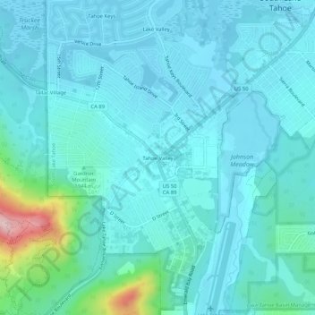
Name: Tahoe Valley topographic map, elevation, terrain.
Average elevation: 1,935 m
Minimum elevation: 1,898 m
Maximum elevation: 2,177 m
Thank you for supporting this site ❤️
Make a donation
Make a donation
Other topographic maps
Click on a map to view its topography, its elevation and its terrain.
South Lake Tahoe-El Dorado Recreation Area
United States > California > El Dorado County > South Lake Tahoe > Bijou
Average elevation: 1,905 m