
Thank you for supporting this site ❤️
Make a donation
Make a donation
Almaty Region topographic map
Click on the map to display elevation.
Thank you for supporting this site ❤️
Make a donation
Make a donation
About this map
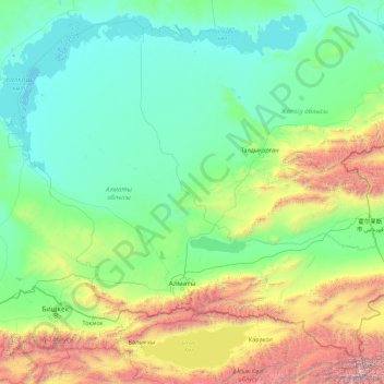
Name: Almaty Region topographic map, elevation, terrain.
Location: Almaty Region, Kazakhstan (42.21084 73.72202 46.73814 80.80728)
Average elevation: 1,137 m
Minimum elevation: 335 m
Maximum elevation: 7,318 m
Thank you for supporting this site ❤️
Make a donation
Make a donation
Other topographic maps
Click on a map to view its topography, its elevation and its terrain.