
Make a donation
Telfes im Stubai topographic map
Click on the map to display elevation.
Make a donation
Telfes im Stubai
The village of Telfes is located in the front Stubaital, on the sunny left side of the Ruetz river. The municipality lies at an altitude of about 1000 m and has an area of 27.38 square kilometers. The hamlets Gerstbichl, Falschmair, Luimes, the scattered houses Telfer Wiesen and the single vineyards Wiesenhof and Gallhof (already above Schönberg) out of the valley belong to the municipality, as well as the Pfarrachalm at the Nederjoch, and the well-known hiking and skiing area Schlick below the Kalkkögel with the alpine inns Schlick (Schlickeralm) and Zirmach at the bottom of the valley, as well as Froneben and Sennjoch at the ridge (at Kreuzjoch only the cable car station).
Make a donation
About this map
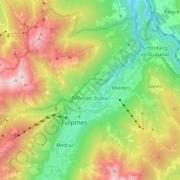
Name: Telfes im Stubai topographic map, elevation, terrain.
Location: Telfes im Stubai, Bezirk Innsbruck-Land, Tyrol, 6165, Austria (47.13342 11.27301 47.20278 11.39599)
Average elevation: 1,430 m
Minimum elevation: 674 m
Maximum elevation: 2,591 m
Make a donation
Other topographic maps
Click on a map to view its topography, its elevation and its terrain.
Hoher Burgstall
Austria > Tyrol > Bezirk Innsbruck-Land > Neustift im Stubaital
Average elevation: 2,142 m
Make a donation
Make a donation
Elferspitze
Austria > Tyrol > Bezirk Innsbruck-Land > Neustift im Stubaital
Average elevation: 1,978 m
Make a donation
Make a donation
Axamer Lizum
Austria > Tyrol > Bezirk Innsbruck-Land > Gemeinde Axams > Axamer Lizum
Average elevation: 1,858 m
Make a donation