
Thank you for supporting this site ❤️
Make a donation
Make a donation
Gaistal topographic map
Click on the map to display elevation.
Thank you for supporting this site ❤️
Make a donation
Make a donation
About this map
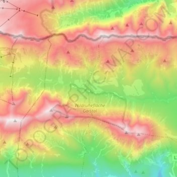
Name: Gaistal topographic map, elevation, terrain.
Location: Gaistal, Leutasch, Bezirk Innsbruck-Land, Tyrol, Austria (47.36298 10.97714 47.37546 11.10989)
Average elevation: 1,731 m
Minimum elevation: 757 m
Maximum elevation: 2,742 m
Thank you for supporting this site ❤️
Make a donation
Make a donation
Other topographic maps
Click on a map to view its topography, its elevation and its terrain.