
宝力根苏木 topographic map
Interactive map
Click on the map to display elevation.
About this map
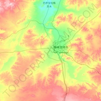
Name: 宝力根苏木 topographic map, elevation, terrain.
Location: 宝力根苏木, 锡林浩特市, 锡林郭勒盟, 内蒙古自治区, 中国 (43.61041 115.31510 44.23584 116.41241)
Average elevation: 1,129 m
Minimum elevation: 931 m
Maximum elevation: 1,467 m
Other topographic maps
Click on a map to view its topography, its elevation and its terrain.