
Hansen topographic map
Interactive map
Click on the map to display elevation.
About this map
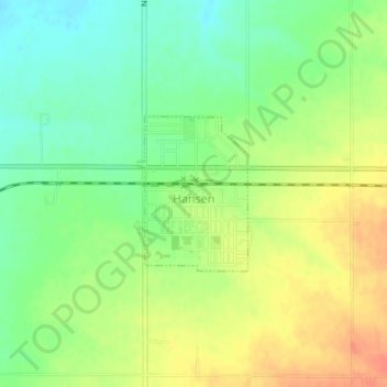
Name: Hansen topographic map, elevation, terrain.
Location: Hansen, Twin Falls County, Idaho, United States (42.52606 -114.30658 42.53688 -114.29614)
Average elevation: 1,227 m
Minimum elevation: 1,205 m
Maximum elevation: 1,250 m
Other topographic maps
Click on a map to view its topography, its elevation and its terrain.
Twin Falls
United States > Idaho > Twin Falls County
Twin Falls, Twin Falls County, Idaho, 83301, United States
Average elevation: 1,138 m
Dolman Island
United States > Idaho > Twin Falls County
Dolman Island, Twin Falls County, Idaho, United States
Average elevation: 897 m
Buhl
United States > Idaho > Twin Falls County
Buhl, Twin Falls County, Idaho, United States
Average elevation: 1,149 m
Filer
United States > Idaho > Twin Falls County
Filer, Twin Falls County, Idaho, United States
Average elevation: 1,149 m
Kimberly
United States > Idaho > Twin Falls County
Kimberly, Twin Falls County, Idaho, 83441, United States
Average elevation: 1,195 m