
Buhl topographic map
Interactive map
Click on the map to display elevation.
About this map
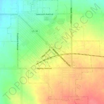
Name: Buhl topographic map, elevation, terrain.
Location: Buhl, Twin Falls County, Idaho, United States (42.58381 -114.77574 42.61167 -114.74207)
Average elevation: 1,149 m
Minimum elevation: 1,115 m
Maximum elevation: 1,182 m
Buhl is located at 42°36′0″N 114°45′43″W / 42.60000°N 114.76194°W / 42.60000; -114.76194 (42.600102, -114.761867), at an elevation of 3,770 feet (1,149 m) above sea level.
Other topographic maps
Click on a map to view its topography, its elevation and its terrain.
Twin Falls
United States > Idaho > Twin Falls County
Twin Falls, Twin Falls County, Idaho, 83301, United States
Average elevation: 1,138 m
Hansen
United States > Idaho > Twin Falls County
Hansen, Twin Falls County, Idaho, United States
Average elevation: 1,227 m
Dolman Island
United States > Idaho > Twin Falls County
Dolman Island, Twin Falls County, Idaho, United States
Average elevation: 897 m
Filer
United States > Idaho > Twin Falls County
Filer, Twin Falls County, Idaho, United States
Average elevation: 1,149 m
Kimberly
United States > Idaho > Twin Falls County
Kimberly, Twin Falls County, Idaho, 83441, United States
Average elevation: 1,195 m