
留隍镇 topographic map
Interactive map
Click on the map to display elevation.
About this map
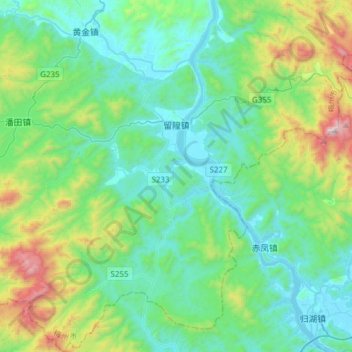
Name: 留隍镇 topographic map, elevation, terrain.
Location: 留隍镇, 丰顺县, 梅州市, 广东省, 中国 (23.73546 116.32968 24.01396 116.62136)
Average elevation: 318 m
Minimum elevation: 11 m
Maximum elevation: 1,444 m
全镇总面积428.23平方公里,其中山地面积555733亩,耕地面积30739亩。地形以低山丘陵为主,地势北高南低,地貌形态较为简单。
Other topographic maps
Click on a map to view its topography, its elevation and its terrain.