
Ad Dakhiliyah Governorate topographic map
Interactive map
Click on the map to display elevation.
About this map
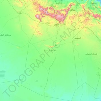
Name: Ad Dakhiliyah Governorate topographic map, elevation, terrain.
Location: Ad Dakhiliyah Governorate, Oman (20.90857 56.52715 23.55060 58.52517)
Average elevation: 315 m
Minimum elevation: 0 m
Maximum elevation: 2,943 m
Other topographic maps
Click on a map to view its topography, its elevation and its terrain.
Jebel Jais
Jebel Jais (Arabic: جَبَل جَيْس, romanized: Jabal Jays) is a mountain of the North-Western Hajar range in the Musandam Governorate of Oman and also in Ras Al Khaimah, United Arab Emirates. The summit has an elevation of 1,934 m (6,345 ft). The summit is located on the Omani side, but a high point…
Average elevation: 1,579 m