
Thank you for supporting this site ❤️
Make a donation
Make a donation
Central Region topographic map
Click on the map to display elevation.
Thank you for supporting this site ❤️
Make a donation
Make a donation
About this map
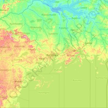
Name: Central Region topographic map, elevation, terrain.
Location: Central Region, Uganda (-1.00002 31.01238 1.67804 33.52066)
Average elevation: 1,134 m
Minimum elevation: 1,031 m
Maximum elevation: 1,603 m
Thank you for supporting this site ❤️
Make a donation
Make a donation
Other topographic maps
Click on a map to view its topography, its elevation and its terrain.
Kisoro
Uganda > Kisoro > Cyanika > Kisoro
Kisoro is approximately 76 kilometres (47 mi), by road, west of Kabale, the largest city in the Kigezi sub-region. This is approximately 484 kilometres (301 mi), by road, southwest of Kampala, the capital of Uganda and the country's largest city. Kisoro is east of Rumangabo and the Virunga Mountains in the…
Average elevation: 1,911 m