
Thank you for supporting this site ❤️
Make a donation
Make a donation
Sealy topographic map
Click on the map to display elevation.
Thank you for supporting this site ❤️
Make a donation
Make a donation
About this map
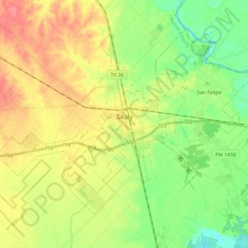
Name: Sealy topographic map, elevation, terrain.
Location: Sealy, Austin County, Texas, 77474, United States (29.72258 -96.24044 29.82635 -96.07605)
Average elevation: 54 m
Minimum elevation: 26 m
Maximum elevation: 88 m
Thank you for supporting this site ❤️
Make a donation
Make a donation
Other topographic maps
Click on a map to view its topography, its elevation and its terrain.
Stephen F Austin State Park
United States > Texas > Austin County > San Felipe
Average elevation: 43 m
Thank you for supporting this site ❤️
Make a donation
Make a donation