
花石镇 topographic map
Interactive map
Click on the map to display elevation.
About this map
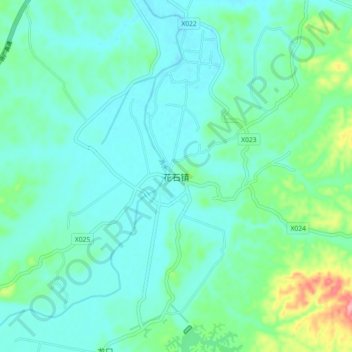
Name: 花石镇 topographic map, elevation, terrain.
Location: 花石镇, 湘潭县, 湘潭市, 湖南省, 中国 (27.47397 112.68163 27.55397 112.76163)
Average elevation: 74 m
Minimum elevation: 50 m
Maximum elevation: 172 m
花石镇,是中华人民共和国湖南省湘潭市湘潭县下辖的一个乡镇级行政单位。最低海拔50.40米,最高海拔425.70米。镇域总面积为133.40平方公里,为西汉时期湘南县城所在地。湘莲产业是花石镇的传统支柱产业。
Other topographic maps
Click on a map to view its topography, its elevation and its terrain.