
Großmonra topographic map
Interactive map
Click on the map to display elevation.
About this map
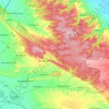
Name: Großmonra topographic map, elevation, terrain.
Location: Großmonra, Kölleda, Landkreis Sömmerda, Thüringen, Deutschland (51.17493 11.26335 51.29366 11.39115)
Average elevation: 240 m
Minimum elevation: 115 m
Maximum elevation: 384 m
Stadtteil: Kiebitzhöhe
Other topographic maps
Click on a map to view its topography, its elevation and its terrain.
Burgwenden
Deutschland > Thüringen > Landkreis Sömmerda > Kölleda
Burgwenden, Kölleda, Landkreis Sömmerda, Thüringen, Deutschland
Average elevation: 264 m
Schloss Beichlingen
Deutschland > Thüringen > Landkreis Sömmerda > Kölleda
Schloss Beichlingen, Schlossberg, Beichlingen, Kölleda, Landkreis Sömmerda, Thüringen, 99625, Deutschland
Average elevation: 243 m