
Landkreis Diepholz topographic map
Interactive map
Click on the map to display elevation.
About this map
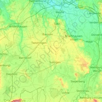
Name: Landkreis Diepholz topographic map, elevation, terrain.
Location: Landkreis Diepholz, Lower Saxony, Germany (52.44280 8.29386 53.05315 9.11619)
Average elevation: 36 m
Minimum elevation: 2 m
Maximum elevation: 173 m
Other topographic maps
Click on a map to view its topography, its elevation and its terrain.
Weyhe
Germany > Lower Saxony > Landkreis Diepholz > Weyhe
Weyhe, Landkreis Diepholz, Lower Saxony, Germany
Average elevation: 8 m