
Make a donation
Afghanistan topographic map
Click on the map to display elevation.
Make a donation
Afghanistan
Several types of mammals exist throughout Afghanistan. Snow leopards, Siberian tigers and brown bears live in the high elevation alpine tundra regions. The Marco Polo sheep exclusively live in the Wakhan Corridor region of north-east Afghanistan. Foxes, wolves, otters, deer, wild sheep, lynx and other big cats populate the mountain forest region of the east. In the semi-desert northern plains, wildlife include a variety of birds, hedgehogs, gophers, and large carnivores such as jackals and hyenas.
Make a donation
About this map
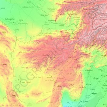
Name: Afghanistan topographic map, elevation, terrain.
Location: Afghanistan (29.37729 60.51760 38.49107 74.88986)
Average elevation: 1,353 m
Minimum elevation: 48 m
Maximum elevation: 7,063 m
Make a donation
Other topographic maps
Click on a map to view its topography, its elevation and its terrain.
Make a donation
Ernakulam
India > Kerala > Kanayannur
The Ernakulam District is situated in Central Kerala in India. Ernakulam is located at the geographic coordinates of 9°58′53.8″N 76°17′59.6″E / 9.981611°N 76.299889°E / 9.981611; 76.299889 and at an elevation of 22.36 m (73.4 ft) above the mean sea level.
Average elevation: 6 m
Make a donation
Manang
Nepal > Gandaki Province > Manang
Manang (Nepali: मनाङ) is a town in the Manang District of Nepal. It is located at 28°40'0N 84°1'0E with an elevation of 3,519 metres (11,545 ft). According to the preliminary results of the 2011 Nepal census, the district has a population of 6,527 people living in 1,495 individual households. Its…
Average elevation: 3,855 m
Make a donation
Make a donation
Moody Lake
United States > Minnesota > Chisago County > Chisago Lake Township
Average elevation: 283 m
Make a donation
Thiruvananthapuram
India > Kerala > Thiruvananthapuram
Thiruvananthapuram is built on seven hills by the seashore and is at 8°30′N 76°54′E / 8.5°N 76.9°E / 8.5; 76.9 on the west coast, near the southern tip of mainland India. The city is on the west coast of India and is bounded by the Laccadive Sea to its west and the Western Ghats to its east.…
Average elevation: 33 m
Make a donation
Gaborone
Botswana > South-East District
Gaborone is situated at 24°39′29″S 25°54′44″E / 24.65806°S 25.91222°E / -24.65806; 25.91222 between Kgale and Oodi Hills, on the Notwane River in the south-eastern corner of Botswana, and 15 kilometres (9.3 mi) from the South African border The city lies at an elevation of 1,010 metres…
Average elevation: 1,032 m
Make a donation
Make a donation
Make a donation
Bucks Bridge
United States > New York > Saint Lawrence County > Town of Potsdam
Average elevation: 98 m
Make a donation
Carolina
South Africa > Mpumalanga > Gert Sibande > Albert Luthuli Local Municipality
Average elevation: 1,675 m
Make a donation
Make a donation
Make a donation
Canberra
The area chosen for the capital had been inhabited by Aboriginal Australians for up to 21,000 years, by groups including the Ngunnawal and Ngambri. European settlement commenced in the first half of the 19th century, as evidenced by surviving landmarks such as St John's Anglican Church and Blundells Cottage.…
Average elevation: 638 m
Make a donation
Make a donation
Make a donation
Nairobi National Park
Kenya > Nairobi County > Kajiado North > Nairobi
The park covers an area of 117.21 km2 (45.26 sq mi) and is small in comparison to most of Africa's national parks. The park's altitude ranges between 1,533 and 1,760 m (5,030 and 5,774 ft). It has a dry climate. The park is the only protected part of the Athi-Kapiti ecosystem, making up less than 10% of this…
Average elevation: 1,662 m
Make a donation
Sierra Nevada de Santa Marta
Colombia > Magdalena > Aracataca
The Sierra Nevada de Santa Marta (English: Snow-Covered Mountain Range of Saint Martha) is an isolated mountain range in northern Colombia, separate from the Andes range that runs through the north of the country. Reaching an elevation of 5,700 m (18,700 ft) just 42 km (26 mi) from the Caribbean coast, the…
Average elevation: 5,013 m
Make a donation
Make a donation
Elephant Pound Rajaji National park Uttrakhand
India > Uttarakhand > Yamkeshwar
Average elevation: 455 m
Make a donation
Little Diomede Island
United States > Alaska > Unorganized Borough > Diomede > Diomede
Average elevation: 160 m
Make a donation
Kayseri
Kayseri sits at the foot of Mount Erciyes (Turkish: Erciyes Dağı), a dormant volcano that reaches an altitude of 3,917 metres (12,851 feet), more than 1,500 metres above the city's mean altitude. It contains a number of historic monuments, particularly from the Seljuk period. Tourists often pass through…
Average elevation: 1,345 m
Giyani
South Africa > Limpopo > Mopani District Municipality > Greater Giyani Local Municipality
Average elevation: 481 m
Make a donation
Make a donation
Demebecha
Dembecha is a town in northwestern Ethiopia 349 km north of Addis Ababa. Located in the Mirab Gojjam Zone of the Amhara Region, this town has a latitude and longitude of 10°33′N 37°29′E / 10.550°N 37.483°E / 10.550; 37.483 with an elevation of 2083 meters above sea level. It is one of three…
Average elevation: 2,125 m
Make a donation
Heard Island
Heard Island, by far the largest of the group, is a 368-square-kilometre (142 sq mi) mountainous island covered by 41 glaciers; 80% of the island is covered with ice. The Big Ben massif dominates the island: It has a maximum elevation of 2,745 metres (9,006 ft) at Mawson Peak, the historically active volcanic…
Average elevation: 120 m
Make a donation