
Logan topographic map
Interactive map
Click on the map to display elevation.
About this map
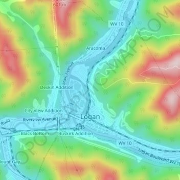
Name: Logan topographic map, elevation, terrain.
Location: Logan, Logan County, West Virginia, United States (37.84171 -81.99897 37.86372 -81.96696)
Average elevation: 316 m
Minimum elevation: 193 m
Maximum elevation: 560 m
Other topographic maps
Click on a map to view its topography, its elevation and its terrain.
Logan
United States > West Virginia > Logan County > Logan > Logan
Logan, Logan County, West Virginia, 25653, United States
Average elevation: 363 m