Geolocate

Morogoro Region topographic map

Interactive map

Click on the map to display elevation.

Morogoro Region

The Morogoro region has a total size of 73,039 square kilometers, which is split between land (70,967 square kilometers, or 97.2 percent of the total area), and water (2,073 km2 or 2.8 percent). As of 2012, Ulanga District is the largest district,Malinyi DC comes in second with 17.0 percent of the region's total land area, followed by Morogoro DC with 16.1 percent. Kilosa District comes in first with 18.6 percent. Morogoro Municipal was the district with the smallest land size (531 km2 or 10.7%), followed by Gairo DC with (1,851 km2 or 2.5 percent). Different scenarios exist in Kilosa DC, Malinyi DC, Ifakara TC, Ulanga DC, Morogoro MC, and Gairo DC, with all of their respective territories being completely covered by land. While Mvomero DC (1,882 km2) has the most water area in the area. At Mlimba DC, there is the smallest water area (70 km2). According to topographical and ecological zones, the region's soils differ.

Wikipedia (CC-BY-SA 3.0)

About this map

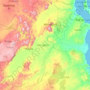
Name: Morogoro Region topographic map, elevation, terrain.

Location: Morogoro Region, Coastal Zone, Tanzania (-9.92346 35.32406 -5.80227 38.51660)

Average elevation: 539 m

Minimum elevation: 0 m

Maximum elevation: 2,560 m

Other topographic maps

Click on a map to view its topography, its elevation and its terrain.

Iringa

Tanzania > Iringa Region

Average elevation: 1,215 m

Zanzibar Urban/West

Tanzania

Average elevation: 16 m

Mbeya Region

Tanzania

The Great Rift Valley created the majority of the places in the area, with the lowland elevation occupying the Western Rift Zone, which includes the Lake Rukwa and Lake Nyasa regions, and the Eastern Rift Zone, which includes the Usangu Plains and other sections of the Ruaha Trough. The heights range from 475…

Average elevation: 1,314 m

Meru

Tanzania > Arusha

Average elevation: 1,342 m

Kagera

Tanzania

Average elevation: 1,284 m

Arusha

Tanzania > Arusha

Despite its proximity to the equator, Arusha's elevation of 1,400 metres (4,600 ft) on the southern slopes of Mount Meru keeps temperatures relatively low and alleviates humidity. Cool dry air is prevalent for much of the year. The temperature typically ranges between 10 and 30 °C (50 and 86 °F) with an…

Average elevation: 1,572 m

Kigoma Region

Tanzania

Kigoma Region is on a plateau that slopes from the northeast at about 1,750 metres (5,740 ft) down to 800 metres (2,600 ft) at the shore of lake Tanganyika. The topography in the north and east is gently rolling hills that gradually become steeper as they get closer to the Albertine Rift margin. The most…

Average elevation: 1,215 m

Dar es Salaam

Tanzania

Average elevation: 57 m

Kilosa

Tanzania > Morogoro Region

Average elevation: 832 m

Kilosa

Tanzania > Mtwara Region

Average elevation: 340 m

Kichangani

Tanzania > Morogoro Region > Kichangani

Average elevation: 323 m

Kichangani

Tanzania > Morogoro Region > Kichangani

Average elevation: 394 m

Dodoma

Tanzania > Dodoma Region > Dodoma

The official capital since 1996, Dodoma was envisaged as the first non-monumental capital city as opposed to the monumentality and hierarchy of other planned capital cities such as Abuja, Brasília and Washington, D.C. It rejected geometrical forms such as grid iron and radial plans as inappropriate as the…

Average elevation: 1,145 m

Serengeti National Park

Tanzania > Mara Region

Average elevation: 1,524 m

Dodoma

Tanzania > Dodoma

Average elevation: 1,053 m

Kilwa

Tanzania > Lindi

Average elevation: 159 m

Serengeti

Tanzania > Mara

Average elevation: 1,472 m

Irango

Tanzania > Kagera > Irango

Average elevation: 1,164 m

Kilosa

Tanzania > Morogoro > Kilosa

Average elevation: 552 m

Mawenzi

Tanzania > Kilimanjaro

Average elevation: 4,479 m

Kipengere

Tanzania > Njombe > Kipengere

Average elevation: 2,192 m

Arumeru

Tanzania > Arusha

Average elevation: 1,369 m

Furtwängler Glacier

Tanzania > Kilimanjaro

Average elevation: 5,569 m

Lushoto

Tanzania > Tanga > Lushoto

Average elevation: 1,492 m

Kidayi 'A'

Tanzania > Morogoro > Kidayi 'A'

Average elevation: 659 m