
Thank you for supporting this site ❤️
Make a donation
Make a donation
Phnom Penh topographic map
Click on the map to display elevation.
Thank you for supporting this site ❤️
Make a donation
Make a donation
About this map
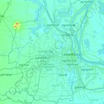
Name: Phnom Penh topographic map, elevation, terrain.
Location: Phnom Penh, Cambodia (11.42009 104.72040 11.73495 105.04403)
Average elevation: 13 m
Minimum elevation: 1 m
Maximum elevation: 134 m
Thank you for supporting this site ❤️
Make a donation
Make a donation
Other topographic maps
Click on a map to view its topography, its elevation and its terrain.