
Karakol topographic map
Interactive map
Click on the map to display elevation.
About this map
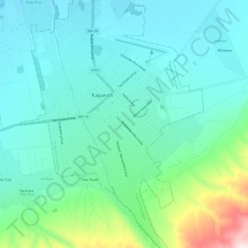
Name: Karakol topographic map, elevation, terrain.
Location: Karakol, Gebiet Yssykköl, Kirgisistan (42.43959 78.35234 42.52374 78.43710)
Average elevation: 1,801 m
Minimum elevation: 1,666 m
Maximum elevation: 2,385 m
Other topographic maps
Click on a map to view its topography, its elevation and its terrain.
Yssykköl
Yssykköl, Gebiet Yssykköl, Kirgisistan
Average elevation: 2,589 m
Khan Tengri
Khan Tengri, Gebiet Yssykköl, Kirgisistan
Average elevation: 5,894 m