
Make a donation
Broad Top City topographic map
Click on the map to display elevation.
Make a donation
Broad Top City
Broad Top City is located in southwestern Huntingdon County at 40°12′6″N 78°8′23″W / 40.20167°N 78.13972°W / 40.20167; -78.13972 (40.201593, -78.139631). It is bordered to the north, west, and south by Carbon Township and to the east by Wood Township. The borough sits on top of a plateau at an elevation of 1,970 feet (600 m) above sea level.
Make a donation
About this map
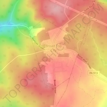
Name: Broad Top City topographic map, elevation, terrain.
Average elevation: 602 m
Minimum elevation: 506 m
Maximum elevation: 645 m
Make a donation
Other topographic maps
Click on a map to view its topography, its elevation and its terrain.
Warriors Mark
United States > Pennsylvania > Huntingdon County > Warriors Mark Township
Average elevation: 370 m
Make a donation
Spruce Creek
United States > Pennsylvania > Huntingdon County > Spruce Creek Township
Average elevation: 329 m
Puttstown
United States > Pennsylvania > Huntingdon County > Hopewell Township
Average elevation: 330 m
Make a donation
Pennsylvania Furnace
United States > Pennsylvania > Huntingdon County > Franklin Township
Average elevation: 363 m
McAlevys Fort
United States > Pennsylvania > Huntingdon County > Jackson Township
Average elevation: 265 m
Make a donation
McConnellstown
United States > Pennsylvania > Huntingdon County > Walker Township
Average elevation: 257 m
Make a donation
Blairs Mills
United States > Pennsylvania > Huntingdon County > Tell Township
Average elevation: 283 m
Lake Jeanette
United States > Pennsylvania > Huntingdon County > Jackson Township
Average elevation: 268 m
Water Street
United States > Pennsylvania > Huntingdon County > Morris Township
Average elevation: 319 m
Make a donation