
Thank you for supporting this site ❤️
Make a donation
Make a donation
Entriken topographic map
Click on the map to display elevation.
Thank you for supporting this site ❤️
Make a donation
Make a donation
About this map
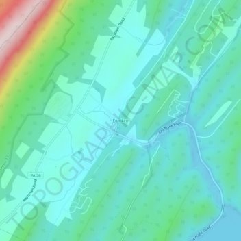
Name: Entriken topographic map, elevation, terrain.
Average elevation: 324 m
Minimum elevation: 239 m
Maximum elevation: 680 m
Thank you for supporting this site ❤️
Make a donation
Make a donation
Other topographic maps
Click on a map to view its topography, its elevation and its terrain.
Raystown Lake
United States > Pennsylvania > Huntingdon County > Lincoln Township
The proposal for the new dam incorporated the ideas of bringing tourism into the area, promoting recreation, and flood control. The actual purpose stated, "The project will provide flood control, recreation, water quality and fish and wildlife enhancement" (U.S. Army Corps of Engineers, 1974). Although tourism…
Average elevation: 380 m