
Bolland topographic map
Interactive map
Click on the map to display elevation.
About this map
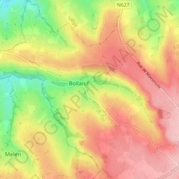
Name: Bolland topographic map, elevation, terrain.
Location: Bolland, Herve, Verviers, Luik, Wallonië, 4650, België (50.64077 5.73002 50.67937 5.77988)
Average elevation: 243 m
Minimum elevation: 163 m
Maximum elevation: 305 m
Bolland ligt in het Land van Herve, in de vallei van de Bollandbeek op een hoogte van ongeveer 200 meter. De valleien van de Bollandbeek en de hierin uitstromende Ruisseau de Noblehaye hebben enkele bossen, het plateau wordt ingenomen door landbouwactiviteit.
Other topographic maps
Click on a map to view its topography, its elevation and its terrain.