
Make a donation
Nankai topographic map
Click on the map to display elevation.
Make a donation
Nankai
Nankai District is located in the south-west corner of the urban Tianjin, bordered by Hongqiao District to the north, Hebei and Heping Districts to the north-east, Hexi District to the east and Xiqing District to the south-west. It occupies an area of 40.64 square kilometres (15.69 sq mi). The natural topography is characterised by higher elevation in the north of the district and a lower elevation in the south, with the average altitude being 3 metres.
Make a donation
About this map
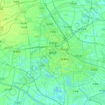
Name: Nankai topographic map, elevation, terrain.
Location: Nankai, Nankai District, Tianjin, 300084, China (38.97701 116.98395 39.29701 117.30395)
Average elevation: 5 m
Minimum elevation: -5 m
Maximum elevation: 19 m
Make a donation
Other topographic maps
Click on a map to view its topography, its elevation and its terrain.