
邵阳县 topographic map
Interactive map
Click on the map to display elevation.
About this map
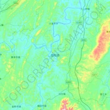
Name: 邵阳县 topographic map, elevation, terrain.
Location: 邵阳县, 邵阳市, 湖南省, 中国 (26.83399 111.10842 27.15399 111.42842)
Average elevation: 314 m
Minimum elevation: 214 m
Maximum elevation: 812 m
邵阳县地处资水上游,地形南高北低,东南部由南部河伯岭山脉与东部四明山脉相接,河伯岭海拔1455米,为辖境至高点;北部资江河滩海拔210米。有河流61条,其中资水及其主要支流夫夷水、郝水、檀江。
Other topographic maps
Click on a map to view its topography, its elevation and its terrain.