
Prairie City topographic map
Interactive map
Click on the map to display elevation.
About this map
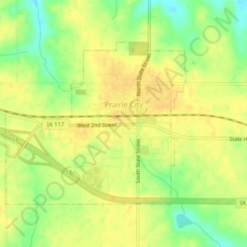
Name: Prairie City topographic map, elevation, terrain.
Location: Prairie City, Jasper County, Iowa, United States (41.58778 -93.25340 41.60557 -93.22707)
Average elevation: 278 m
Minimum elevation: 260 m
Maximum elevation: 287 m
Other topographic maps
Click on a map to view its topography, its elevation and its terrain.
Newton
United States > Iowa > Jasper County
Newton, Jasper County, Iowa, 50208, United States
Average elevation: 277 m
Baxter
United States > Iowa > Jasper County
Baxter, Jasper County, Iowa, United States
Average elevation: 302 m
Galesburg
United States > Iowa > Jasper County
Galesburg, Jasper County, Iowa, 50232, United States
Average elevation: 256 m
Colfax
United States > Iowa > Jasper County
Colfax, Jasper County, Iowa, 50054, United States
Average elevation: 256 m
Monroe
United States > Iowa > Jasper County
Monroe, Jasper County, Iowa, United States
Average elevation: 273 m
Kellogg
United States > Iowa > Jasper County > Kellogg > Kellogg
Kellogg, Jasper County, Iowa, 50135, United States
Average elevation: 270 m
Kellogg
United States > Iowa > Jasper County
Kellogg, Jasper County, Iowa, United States
Average elevation: 266 m