Geolocate

Baxter topographic map

Interactive map

Click on the map to display elevation.

About this map

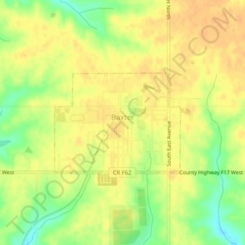
Name: Baxter topographic map, elevation, terrain.

Location: Baxter, Jasper County, Iowa, United States (41.81999 -93.16168 41.83096 -93.14306)

Average elevation: 302 m

Minimum elevation: 280 m

Maximum elevation: 312 m

Other topographic maps

Click on a map to view its topography, its elevation and its terrain.

Newton

United States > Iowa > Jasper County

Newton, Jasper County, Iowa, 50208, United States

Average elevation: 277 m

Galesburg

United States > Iowa > Jasper County

Galesburg, Jasper County, Iowa, 50232, United States

Average elevation: 256 m

Colfax

United States > Iowa > Jasper County

Colfax, Jasper County, Iowa, 50054, United States

Average elevation: 256 m

Monroe

United States > Iowa > Jasper County

Monroe, Jasper County, Iowa, United States

Average elevation: 273 m

Kellogg

United States > Iowa > Jasper County > Kellogg > Kellogg

Kellogg, Jasper County, Iowa, 50135, United States

Average elevation: 270 m

Kellogg

United States > Iowa > Jasper County

Kellogg, Jasper County, Iowa, United States

Average elevation: 266 m

Prairie City

United States > Iowa > Jasper County

Prairie City, Jasper County, Iowa, United States

Average elevation: 278 m