
月山乡 topographic map
Interactive map
Click on the map to display elevation.
About this map
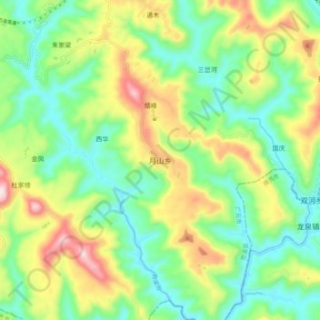
Name: 月山乡 topographic map, elevation, terrain.
Location: 月山乡, 苍溪县, 广元市, 四川省, 中国 (31.78079 106.20410 31.86079 106.28410)
Average elevation: 534 m
Minimum elevation: 384 m
Maximum elevation: 807 m
Other topographic maps
Click on a map to view its topography, its elevation and its terrain.