
Parkersburg topographic map
Interactive map
Click on the map to display elevation.
About this map
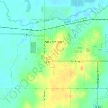
Name: Parkersburg topographic map, elevation, terrain.
Location: Parkersburg, Butler County, Iowa, United States (42.56304 -92.79555 42.58152 -92.75646)
Average elevation: 295 m
Minimum elevation: 282 m
Maximum elevation: 317 m
Other topographic maps
Click on a map to view its topography, its elevation and its terrain.
Austinville
United States > Iowa > Butler County
Austinville, Butler County, Iowa, 50608, United States
Average elevation: 312 m
Greene
United States > Iowa > Butler County
Greene, Butler County, Iowa, United States
Average elevation: 301 m
Shell Rock
United States > Iowa > Butler County
Shell Rock, Butler County, Iowa, United States
Average elevation: 279 m
Aplington
United States > Iowa > Butler County
Aplington, Butler County, Iowa, United States
Average elevation: 302 m
Aredale
United States > Iowa > Butler County
Aredale, Butler County, Iowa, United States
Average elevation: 315 m
Allison
United States > Iowa > Butler County
Allison, Butler County, Iowa, United States
Average elevation: 317 m
Kesley
United States > Iowa > Butler County
Kesley, Butler County, Iowa, 50649, United States
Average elevation: 305 m
Clarksville
United States > Iowa > Butler County
Clarksville, Butler County, Iowa, United States
Average elevation: 285 m
Dumont
United States > Iowa > Butler County
Dumont, Butler County, Iowa, United States
Average elevation: 301 m
New Hartford
United States > Iowa > Butler County
New Hartford, Butler County, Iowa, United States
Average elevation: 276 m
Bristow
United States > Iowa > Butler County
Bristow, Butler County, Iowa, United States
Average elevation: 312 m