Geolocate

Aplington topographic map

Interactive map

Click on the map to display elevation.

About this map

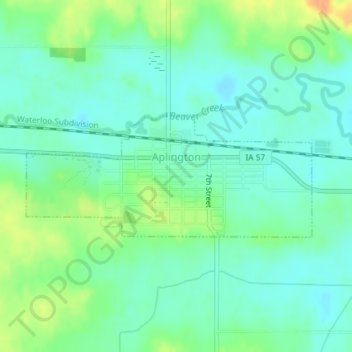
Name: Aplington topographic map, elevation, terrain.

Location: Aplington, Butler County, Iowa, United States (42.57788 -92.89940 42.58721 -92.86963)

Average elevation: 302 m

Minimum elevation: 290 m

Maximum elevation: 325 m

Other topographic maps

Click on a map to view its topography, its elevation and its terrain.

Parkersburg

United States > Iowa > Butler County

Parkersburg, Butler County, Iowa, United States

Average elevation: 295 m

Austinville

United States > Iowa > Butler County

Austinville, Butler County, Iowa, 50608, United States

Average elevation: 312 m

Greene

United States > Iowa > Butler County

Greene, Butler County, Iowa, United States

Average elevation: 301 m

Shell Rock

United States > Iowa > Butler County

Shell Rock, Butler County, Iowa, United States

Average elevation: 279 m

Aredale

United States > Iowa > Butler County

Aredale, Butler County, Iowa, United States

Average elevation: 315 m

Allison

United States > Iowa > Butler County

Allison, Butler County, Iowa, United States

Average elevation: 317 m

Kesley

United States > Iowa > Butler County

Kesley, Butler County, Iowa, 50649, United States

Average elevation: 305 m

Clarksville

United States > Iowa > Butler County

Clarksville, Butler County, Iowa, United States

Average elevation: 285 m

Dumont

United States > Iowa > Butler County

Dumont, Butler County, Iowa, United States

Average elevation: 301 m

New Hartford

United States > Iowa > Butler County

New Hartford, Butler County, Iowa, United States

Average elevation: 276 m

Bristow

United States > Iowa > Butler County

Bristow, Butler County, Iowa, United States

Average elevation: 312 m