
Muna topographic map
Interactive map
Click on the map to display elevation.
About this map
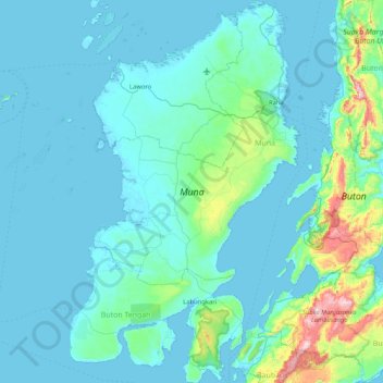
Name: Muna topographic map, elevation, terrain.
Location: Muna, Südost-Sulawesi, Indonesien (-5.44129 122.26574 -4.61046 122.76961)
Average elevation: 70 m
Minimum elevation: -1 m
Maximum elevation: 744 m
Die 2.889 km² große Insel erreicht im Gegensatz zu ihrer gebirgigen Nachbarinsel Buton nur eine Höhe von 91 m über dem Meer.[1]
Other topographic maps
Click on a map to view its topography, its elevation and its terrain.
Buke
Indonesien > Südost-Sulawesi > Konawe Selatan
Buke, Konawe Selatan, Südost-Sulawesi, Sulawesi, Indonesien
Average elevation: 91 m
Kendari
Indonesien > Südost-Sulawesi > Kendari
Kendari, Südost-Sulawesi, Indonesien
Average elevation: 68 m