
Thank you for supporting this site ❤️
Make a donation
Make a donation
Mutters topographic map
Click on the map to display elevation.
Thank you for supporting this site ❤️
Make a donation
Make a donation
About this map
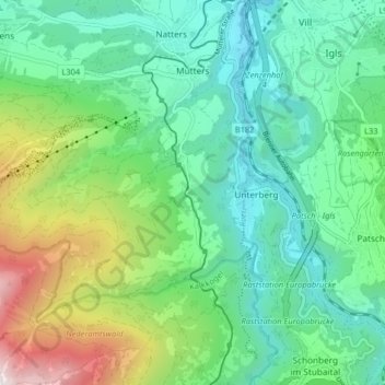
Name: Mutters topographic map, elevation, terrain.
Location: Mutters, Bezirk Innsbruck-Land, Tyrol, 6162, Austria (47.18347 11.32442 47.23846 11.39187)
Average elevation: 1,036 m
Minimum elevation: 633 m
Maximum elevation: 2,121 m
Thank you for supporting this site ❤️
Make a donation
Make a donation
Other topographic maps
Click on a map to view its topography, its elevation and its terrain.
Hoher Burgstall
Austria > Tyrol > Bezirk Innsbruck-Land > Neustift im Stubaital
Average elevation: 2,142 m
Thank you for supporting this site ❤️
Make a donation
Make a donation
Thank you for supporting this site ❤️
Make a donation
Make a donation
Elferspitze
Austria > Tyrol > Bezirk Innsbruck-Land > Neustift im Stubaital
Average elevation: 1,978 m
Thank you for supporting this site ❤️
Make a donation
Make a donation
Thank you for supporting this site ❤️
Make a donation
Make a donation
Axamer Lizum
Austria > Tyrol > Bezirk Innsbruck-Land > Gemeinde Axams > Axamer Lizum
Average elevation: 1,858 m
Thank you for supporting this site ❤️
Make a donation
Make a donation