Geolocate

Echuca topographic map

Interactive map

Click on the map to display elevation.

About this map

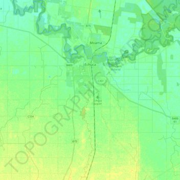
Name: Echuca topographic map, elevation, terrain.

Location: Echuca, Shire of Campaspe, Victoria, Australia (-36.24870 144.67335 -36.06077 144.85024)

Average elevation: 100 m

Minimum elevation: 92 m

Maximum elevation: 109 m

Other topographic maps

Click on a map to view its topography, its elevation and its terrain.

Shire of Moorabool

Australia > Victoria

Average elevation: 427 m

Panmure

Australia > Victoria

Average elevation: 80 m

Shire of Baw Baw

Australia > Victoria

Average elevation: 410 m

Doncaster

Australia > Victoria > Melbourne

Average elevation: 77 m

Halls Gap

Australia > Victoria

Average elevation: 406 m

Bayles

Australia > Victoria > Melbourne

Average elevation: 13 m

Corinella

Australia > Victoria

Average elevation: 9 m

Mount Bogong

Australia > Victoria

The Big River separates the massif of the mountain from the Bogong High Plains to the south. From the nearby town of Mount Beauty to its summit, Mount Bogong rises more than 1,600 metres (5,200 ft),[citation needed] thus making it one of the highest peaks in Australia not only in terms of its elevation above…

Average elevation: 1,719 m

Boorolite

Australia > Victoria

Average elevation: 484 m

Shire of Mansfield

Australia > Victoria

Average elevation: 748 m

Bundoora

Australia > Victoria

Average elevation: 93 m

Mount Fraser

Australia > Victoria

Average elevation: 309 m

Mount Strickland

Australia > Victoria

Average elevation: 868 m

Lara District

Australia > Victoria > Geelong

Average elevation: 94 m

Morwell

Australia > Victoria > Morwell

Average elevation: 62 m