Geolocate

Candaba topographic map

Interactive map

Click on the map to display elevation.

About this map

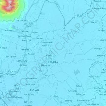
Name: Candaba topographic map, elevation, terrain.

Location: Candaba, Pampanga, Central Luzon, 2013, Philippines (15.00828 120.78129 15.20970 120.95257)

Average elevation: 24 m

Minimum elevation: 0 m

Maximum elevation: 989 m

Other topographic maps

Click on a map to view its topography, its elevation and its terrain.

Paligui

Philippines > Pampanga > Apalit

Average elevation: 3 m

San Agustin

Philippines > Pampanga > San Fernando

Average elevation: 15 m

Calulut

Philippines > Pampanga > San Fernando

Average elevation: 40 m

Sta. Rita EcoPark

Philippines > Pampanga > San Isidro

Average elevation: 21 m

Consuelo

Philippines > Pampanga

Average elevation: 31 m

Camias

Philippines > Pampanga

Average elevation: 252 m

San Fernando

Philippines > Pampanga > San Fernando

Average elevation: 24 m